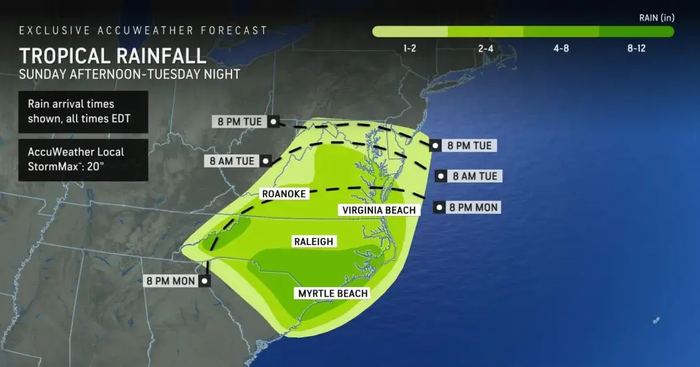
Strong tropical rainstorm with a high chance of dangerous flooding is expected to move inland across the Carolinas and Virginia. Through Tuesday, the storm is predicted to continue to cause both coastal and inland areas to experience torrential downpours, gusty winds, and choppy surf. Significant rainfall and extreme weather have already been brought on by this system, and its effects will only get worse as it moves forward.
As the storm moves inland, meteorologists with AccuWeather have warned of the growing risk of flooding. The system has been contributing to severe thunderstorms and tornado warnings even though the National Hurricane Center (NHC) has not officially classified it as such. Features of the system include a significant sweep of dry air on one side and the absence of a closed circulation.
Wrightsville Beach, North Carolina, saw gusts as high as 67 mph on Monday morning, which is close to the threshold of a powerful tropical storm. This represents the storm’s intensity, with 39 to 73 mph tropical storm-force winds. Along the coast of North Carolina, rainfall totals have already reached 15-20 inches. The system is behaving like a gigantic firehose, drenching communities in rain without stop.
The storm’s wind intensity is predicted to decrease as it approaches land. However, the heavy rain and associated flooding are likely to continue and expand. AccuWeather has rated the storm as a 1 on its RealImpact™ Scale for Hurricanes, emphasizing the significant risks to lives and property despite the system’s current lack of formal hurricane designation.
High tides and wave action could put beachfront properties, especially in North Carolina’s Outer Banks, at greater risk. Coastal roads could also be blocked or washed out.The storm’s heaviest impacts, including the most intense downpours and strongest winds, have been concentrated to the north and northwest of its center. As it progresses, tides along the Southeast coast are expected to remain above historical averages due to the full moon. Coastal roads may be obstructed by high water or washed out, and beachfront properties, particularly in the Outer Banks of North Carolina, could face increased risk from high tides and wave action.
Apart from the coastal hazards, the storm is expected to cause significant rainfall inland; estimates range from 2-4 inches over a wide swath from the Carolinas to Virginia. Localized areas, especially in eastern regions and the southern Appalachians, may receive 4-8 inches of rain. This rainfall could lead to small streams overflowing, urban flooding, and significant rises in river levels.
The storm’s influence is also expected to extend northward, bringing some rain to Maryland, Delaware, New Jersey, southern and eastern Pennsylvania, and central and eastern West Virginia on Tuesday. This would mark the first significant rainfall in over a week for many of these areas.
Looking ahead, the current storm could help generate a new weather system along the mid-Atlantic coast later this week. This potential new storm may enhance rainfall in portions of the central Appalachians and southeastern New England, with the possibility of coastal flooding and rough surf extending from New England to the Carolinas.
Along with a new area of interest in the central Caribbean, southwestern Atlantic, and eastern Gulf of Mexico, observers are keeping an eye on the weakening tropical depression Gordon in the broader tropics. Because of the warm waters, if a new tropical storm forms, it might intensify quickly and have an effect on the United States and its surroundings. Residents are advised to keep informed and ready for ongoing severe weather and flooding risks, as meteorologists are closely monitoring these developments.
