Major Winter Storm Brings Snow, Ice and Travel Chaos

A powerful winter storm — part of Winter Storm Fern — is sweeping across large swaths of the United States, bringing heavy snow, crippling ice, and extremely cold temperatures to regions stretching from the Southern Plains into the Northeast and Mid-Atlantic over the weekend and into early next week. More than 140 million people are under winter storm warnings, and numerous states have declared emergencies in preparation.
This system is producing widespread hazardous conditions including heavy snow, sleet, freezing rain, and Arctic chill, with impacts expected to persist long after the storm passes.
Major Travel Disruptions
Air travel is being severely affected. Airlines have canceled thousands of flights across the country — including in major hub cities like Atlanta, Boston, New York, and others — with more cancellations and delays expected as the storm intensifies.
Travel on roadways is also turning dangerous, with snow, ice, and freezing rain creating very slippery surfaces. Power outages and delays in snow removal are likely in areas receiving the heaviest accumulations.
Heavy Snow and Ice Threats
- Southern Plains: Snow and ice have already begun falling in parts of Texas and Oklahoma, with accumulations up to a foot or more in some areas as freezing rain and sleet combine.
- Mid-Atlantic & D.C. Region: The Washington, D.C. area is forecast to see 5–13 inches of snow and sleet, followed by freezing rain that may coat roads and trees, increasing the risk of outages and downed power lines.
- Northeast: Cities like New York and Boston could receive a foot or more of snow as the storm pushes eastward, with some places seeing historic snowfall totals for the season.
Ice accumulations are a major concern across large parts of the Southern Plains, Southeast, and Mid-Atlantic, where freezing rain may weigh heavily on trees and power infrastructure, raising the danger of prolonged outages and travel hazards.
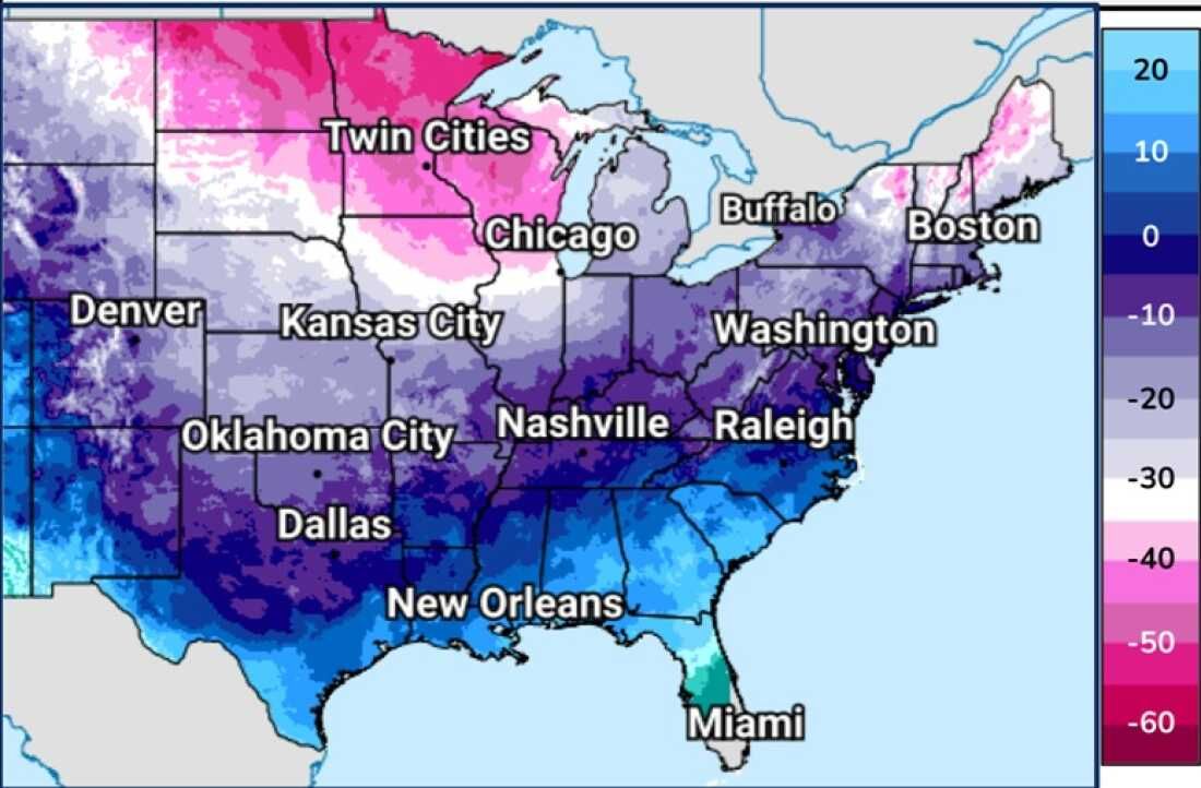
Extreme Cold Following the Storm
Behind the precipitation, Arctic air is moving in, bringing temperatures well below normal — highs in the teens and low 20s in some regions — and will continue past the weekend into early next week, making recovery and snow/ice melt slow and challenging.
Wind chills and subzero overnight lows will increase the risk of frostbite and hypothermia for those exposed. Even areas not receiving heavy snowfall will experience dangerous cold conditions.
Precautions and Preparedness
Meteorologists urge residents in affected areas to:
• Avoid nonessential travel while snow, sleet, and ice are falling.
• Prepare for interruptions in power and heat.
• Keep supplies on hand (food, water, necessary medications).
• Watch for local advisories and school/transport closures.
Winter storm warnings and advisories cover more than 30 states, and forecasters caution that this could be one of the most disruptive storms of the season with widespread impacts from Texas to New England.
What’s Next
The storm is expected to shift eastward through Sunday into Monday, before gradually easing. Snow, ice, and frigid temperatures could linger for days afterward, and cleanup may be prolonged because of the unusually cold air mass settling into many regions.
Keep monitoring updates from the National Weather Service and local authorities for the latest warnings, timing changes, and safety guidance as this weather event continues to unfold.