First Big Snow Hits for Holiday Travelers in the Twin Cities

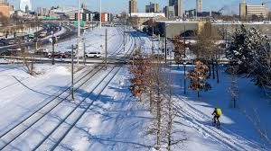
Just as holiday travel picks up pace in the Twin Cities—the region around Minneapolis and St. Paul—weather is stepping into the scene in a big way. Forecasts call for the first significant snowfall of the season, and it arrives right when people are heading out for the holidays. The timing couldn’t be more precarious.
Snow On The Way
Meteorologists warn that rain expected on Tuesday night will transition into snow as colder air moves in. A winter storm warning has been issued for the region, with predictions that most of the metro area will receive between 4 and 6 inches of snow by Wednesday morning. Some of the northern suburbs and areas farther into central Minnesota could see even higher totals.
What Makes This Snowfall Especially Risky
This isn’t just “cute first snow”—it’s showing up when roads haven’t yet been treated for winter conditions, which increases the danger. Strong winds and plunging temperatures—expected to dip into the 20s (°F) overnight—will combine with fresh accumulation to create slick surfaces.
Because it’s the first major snow of the season, drivers may be caught unprepared. Pavements remain untreated, and people may underestimate how quickly conditions can deteriorate.
Broader Context: A Cold Season Begins
The Twin Cities aren’t operating in isolation—this cold and snow-bearing system is part of a large mass of cold air that is expected to span much of the United States during the holiday weekend.
For the area, this means not just a one-day disruption but potentially a stretch of colder weather. Down the road, a high of just 17 °F is projected for Sunday, turning the early season warning into something more sustained.
What Holiday Travelers Should Keep in Mind
For travelers in the Twin Cities region, this snow adds an extra layer of need for caution. Here are key take-aways:
- Plan for delays. Road travel may become slower and more hazardous with the fresh accumulation and untreated surfaces.
- Check before you go. Weather updates, road conditions and transit options could all shift rapidly.
- Adjust expectations. Even if the snowfall itself isn’t monumental relative to deep-winter storms, the timing and early season context make it meaningful.
Final Thoughts
What might normally be just “the first snow” has taken on larger significance because it intersects with holiday travel, cold air buildup and the start of winter operations on roads and transit. While 4-6 inches may not seem dramatic for a region accustomed to snow, the early-season timing and untreated infrastructure raise the stakes.
If you’re heading out in the Twin Cities area this week, give yourself extra time, stay tuned to local forecasts, and expect slower travel. The holiday mood may be up, but the weather’s reminding us it’s still winter.